


Export Shapefile or Geodatabase File
There are three ways to export a geography as a shapefile or geodatabase:
choose (1) "Export>Geography" from the "File" menu,
(2) or "Export geography" from the menu that pops-up when you
right-click the geography, or (3) click on the export  button and choose "Geography" from the drop-down menu on the
project toolbar. Once the Export geography dialog appears, select
the appropriate Export format (shapefile or geodatabase).
button and choose "Geography" from the drop-down menu on the
project toolbar. Once the Export geography dialog appears, select
the appropriate Export format (shapefile or geodatabase).
SpaceStat exports the data and locations of the objects in your geography at the time(s) you specify. It exports the data as a time-slice file with one or several time slices. For shapefiles, the resulting DBF will have one or several rows for each object in your geography with a start and end time for each change in its attributes or position. For instance, if the dataset "RBF" changes every 5 years between 1950 and 1995, then each object will have 9 rows in the DBF, one for each RBF value. The DBF will include all the data you can see in the table in SpaceStat, plus the start and end date and/or time when those data values apply.
Instructions:
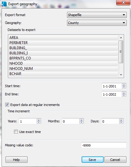
You will need to specify which geography to export at which date and time, and specify a missing value code if appropriate for a shapefile.
Geography
Choose the geography to export from the pull-down list.
Datasets
Choose which datasets to export by selecting them, select a range of datasets using Shift-select or individual datasets using Control-select.
Time slices
To choose the time exported, select the start and end time range.
Time increment
You may also choose to export data at regular increments (how often SpaceStat should "slice" the data). This determines the number of rows per object that SpaceStat creates. If you export a 12 hour range every hour, each object in the geography could have up to 13 rows in the DBF associated with the shapefile, one for each time slice chosen. Objects may have less than the maximum number of rows if they do not exist for the entire time range exported.
Use exact time
As there is some variation in the number of days in a year, and days in a month, for data in these units SpaceStat offers you the option of exporting data in "exact time." If you select this option, the animation will jump forward by a set time increment in days (you could input 365 days for a year, or 30 days for a month). If you leave "use exact time" cleared, the animation will jump forward by the pre-set step size to the anniversary of the initial date. If the step size is 1 year and the first time is January 1, it will jump forward to the next January 1. If "use exact time" is checked, and you enter 365 days as your interval, the date corresponding to the jump will wander a bit from January 1 as leap years occur.
Troubleshooting shapefile export
Note that when datasets are exported as a shapefile, their names are truncated at 10 characters. If this will lead to confusion (i.e., datasets with the same name), you should edit your dataset names by right clicking on them and selecting "rename dataset". Also, some GIS software may have trouble importing datasets if there are spaces in the dataset names. Again, you can remove these by editing the dataset name prior to import.