Create a Centroid Geography
A polygon geography can be transformed to a point geography by generating a centroid geography from the polygon dataset. SpaceStat creates points from polygons by finding the polygon's center of mass. The point could be outside the polygon for certain polygon shapes. For instance, a polygon shaped like a donut would have its center of mass in the "hole".
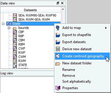
 Right click the polygon geography in the Data view, and select "create
centroid geography" from the pop-up menu, OR select this option from
the tools menu.
Right click the polygon geography in the Data view, and select "create
centroid geography" from the pop-up menu, OR select this option from
the tools menu.
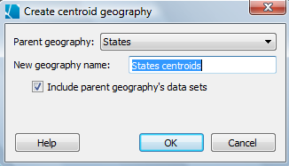
Select the parent polygon geography from the drop-down menu in the pop-up dialog, and enter a name for the new centroid geography. If you want all of the datasets associated with the polygon geography to also be linked to the centroids, check this option in the dialog box.
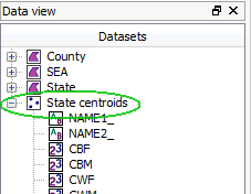
 SpaceStat will create a new point geography underneath the polygon geography,
as shown below. This new centroid geography will have two datasets, the
X and Y coordinates (cut-off in the image below), and also will include
all of the other data sets in the parent geography if you checked this
option.
SpaceStat will create a new point geography underneath the polygon geography,
as shown below. This new centroid geography will have two datasets, the
X and Y coordinates (cut-off in the image below), and also will include
all of the other data sets in the parent geography if you checked this
option.
If you did not check the "Include parent geography's data sets" option, you can add data sets by dragging them down from the parent geography; they will copy into the point geography and remain in the polygon geography. You can also drag datasets the opposite way once they have been created --from the centroid geography to the original polygon geography.