


Perform Scale Conversion/Interpolation
Scale conversion/interpolation methods are located under Methods -> Scale conversion/Interpolation. Here we provide examples of the Task Manager screens for various applications of the interpolation methods.
Input for Scale Conversion
When the task manager opens for the method, it will start on the "Input" section.
Click on the image below for more information on the parameters.
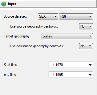
Note that if either of the source or destination geographies consists of polygons, then the "Use source/destination geography centroids" option will force that geography to be treated as a point geography with the polygon’s values assigned to the centroid of that polygon.
Conversion Panel
There are three types of interpolation available: assignment, average/sum, or kriging. These options may vary depending on the combination of source and destination geography.
Kriging method
The kriging method is available for all source/destination geography combinations.
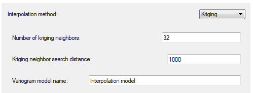
Define the number of kriging neighbors you would like to contribute to the interpolated value and the search distance window. The number of neighbors will be limited to those that are within the search distance if SpaceStat cannot find the number of neighbors specified. You may also name the variogram model that will be produced by this method. You will be able to view this variogram model by right clicking on its name in the Variogram model view.
Assingment method
The assignment method is used when the conversion is to be from a polygon geography to a point geography.
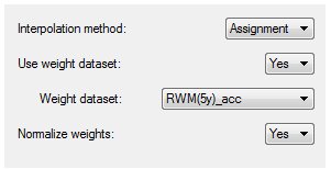
With the assignment interpolation method, each point from the destination geography that is contained within a polygon from the source geography will be assigned the value of the source polygon.
You may also choose to use to weight your observations with a weight dataset from the source geography. You may also normalize the weights if desired.
Average/sum method
The Average/sum method can be applied to the other source/destination geography combinations (polygon -> polygon, point-> point, and point-> polygon).

If you choose to normalize the weights, the values for the destination geography will be averaged. If the weights are not normalized, this method will provide a sum of the objects interpolated to the point or polygon in the destination geography (helpful for aggregating counts to larger scale geographies).
Point to Point Conversion
The screen shots above have all related to geographies that are polygon -> point (Assignment method) or polygon/point -> polygon. If the conversion is to be from a point geography to a point geography, the conversion panel will hold different parameters.
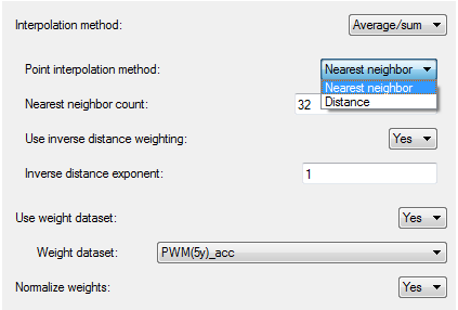
If you choose the average/sum method instead of kriging, you must then choose from two different point interpolation methods: nearest neighbor and distance. Define the number of neighbors or the distance range to select which source points will determine the value of your destination points.
You may also choose to use inverse distance weighting and will be able to manipulate the inverse distance exponent.
The same options to use a weight dataset and to normalize the weights are also available.
Review Settings
As always, the Review settings page presents a summary of the previous tabs so that you can review the choices you have selected. If everything here looks correct, select the "Run" button at the bottom of the page.