Querying Maps
Querying calls up information about items on the map, producing a table of all the data that pertain to the selected location.
 Click on the query tool in the map
tools toolbar, and then click on the map (or right-click on the map
to show the "Query this location" option). This brings up a
table of information on the selected map layer (the highlighted layer).
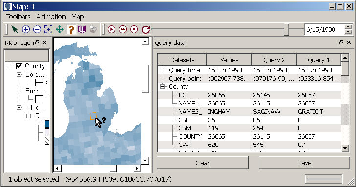
Note that you can query more than one geography from the same project
simultaneously, with the outlines of both selected elements appearing
in the map, and values from each dataset shown sequentially within a column
in the query output table.
Click on the query tool in the map
tools toolbar, and then click on the map (or right-click on the map
to show the "Query this location" option). This brings up a
table of information on the selected map layer (the highlighted layer).
Note that you can query more than one geography from the same project
simultaneously, with the outlines of both selected elements appearing
in the map, and values from each dataset shown sequentially within a column
in the query output table.
Saving and clearing queries
If you wish to compare several locations in the query table, you can press the "Save" button on the lower right of the query window. Then, when you query a new location, the information from the previous query is moved to the right and given a query number, as in the column labeled "Query 1" below. As more queries are done and saved, the Query 1 column will continue moving right, and additional queries will be saved next to the "Values" column. The image below shows a vertical scroll bar that you can use to see values for datasets that do not fit in the query data window; a horizontal scroll bar will also appear if you run out of window space so that you can scroll through your saved queries. The most recent query will always appear in the "Values" column, next to the listing of dataset names. If you hit the "clear" button, all saved queries will be removed from the query window. You can also bring up an option to clear the query output by right-clicking in the query data window.