


Define Point Weights
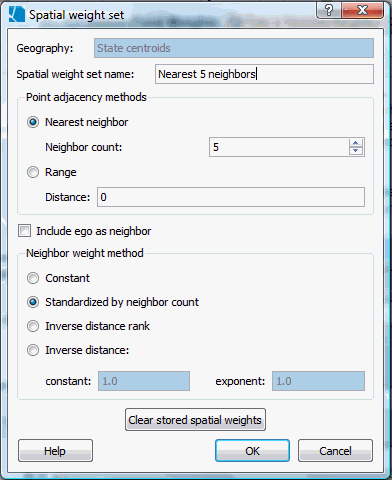
You set spatial weights for a point geography by choosing how to define a neighbor and by defining weight values for these neighbors. To create a new weight set, open the spatial weights and cluster sets view by selecting it under the "Window" menu. Next, right click on the geography for which you would like to create a new weight set and select "Define new spatial weight set" option, which will open the dialog box shown below.
To create new spatial weights, choose among these options. To edit an existing weights set, you can change the options using this same dialog and then save your changes by clicking "OK".
|
You can specify whether neighbor relationships are defined by a set number of nearest neighbors or the number of points within a specified distance range. The units for the range are the units of the geographic coordinates. Click here to see details on how nearest neighbor ties are handled in SpaceStat. |
||
|
Generally, spatial weights sets do not have a weight between ego and itself. Some statistical methods, such as the local G* do. Leave this blank unless you intend to calculate one of these methods. |
||
|
Constant |
This is the simplest method. The more neighbors a point has, the more influence they have. |
|
|
Standardized by neighbor count |
If you standardize by neighbor count, SpaceStat will normalize the weights for each location (each "ego") by its neighbor count. The sum of the weights for each location (each "ego") is 1. |
|
|
Inverse distance rank |
This option assigns weights to nearest neighbors equal to the inverse of their rank. So the nearest neighbor's weight is 1, the second nearest neighbor's weight is 1/2, the third nearest neighbor's weight is 1/3, etc. For a specified nearest neighbor count, this weight value is essentially standardized because all objects in the dataset have the same neighbor count. For range-based neighbor criterion, this weight value is not standardized, as points will have different numbers of neighbors. |
|
|
Inverse distance |
The farther a point is from its neighbor, the less influence it has. You can specify how quickly the weight declines with distance using the equation: a/(1+dpower). In the dialog, you can set the power (exponent) to which SpaceStat will raise the distance and a constant scaling factor, a. This scaling factor is useful when you have a small distance unit (such as meters) and long distances between points; a scaling factor keeps the weights from going to near zero almost immediately. Note: You can enter powers of ten into the dialog by typing "e" to mean "to the power of". |
|
A Note on Missing Values in Analyses that use Adjacency Information
Note that spatial weight sets are created by adjacency evaluations that are independent of any values of datasets associated with the geography, including missing values. Therefore, if you have a dataset with missing values, any analyses that incorporate the weight set may actually use a smaller number of neighbors than was specified, due to the presence of missing values. Some analytical tools in SpaceStat use the distribution of observed statistics to create a distribution and evaluate rarity, so removing one or more locations from a geography (thus creating missing values) can change results for all locations in clustering methods (not just those adjacent to the missing value). The Local Moran, which uses nearest neighbor point adjacencies, is one example of an analysis that is sensitive to missing values.