


Data View
The Data view is the table of contents for all of the data in your project. The Data view holds geographies and associated datasets.
You can undock the Data view window by
clicking on the  symbol in
the upper right corner, and hide it by clicking on the
symbol in
the upper right corner, and hide it by clicking on the  button. Undocking allows you to move the window to another location on
your SpaceStat screen. To unhide the Data view, select Data view
from the "Window" menu.
button. Undocking allows you to move the window to another location on
your SpaceStat screen. To unhide the Data view, select Data view
from the "Window" menu.
You can manage data in the data view by nesting and creating folders.
Symbols explained
|
|
The geographies are identified with their spatial data format. |
|
|
Integer data, numeric data consisting of whole numbers. |
|
|
Decimal data, numeric data that can include fractional numbers. |
|
|
String or text data can consist of letters and/or numbers. For numbers, differences between the values do not have mathematical meaning (they can be descriptors for different categories). |
|
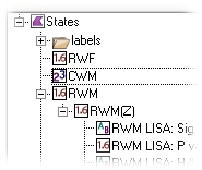
Naming |
The names of datasets derived from other data contain the name of the original dataset. In the example above, "RWM(Z)" is the z-score standardized version of "RWM" dataset. The other datasets shown (LISA index) come from the Local Moran statistic performed on the standardized dataset. Names get rather long using these conventions, but the relationships are clear. You may rename your datasets if desired. To see the parentage of a dataset, you can also right-click on it to view its properties, which describe its origin if the dataset was created within SpaceStat. |


