


Map Properties for Polygons - General Tab
You can view the properties by selecting "Properties" from
the "Map" menu, by clicking on the Map Properties  button on the map toolbar, or by right-clicking on the map.
In the general map properties tab for polygon geographies, you can set how you want to select polygons in the map, how to color selected polygons, and whether to link or hide missing values. When you change your selection options in the dialog, the preview map will update and show you how your changes will look on an example dataset.
Choose "Preview" to view your selections on the map (but keep the properties dialog open), and then choose "OK" to apply your changes and close the dialog. If you press "Cancel" after "Preview" your changes will not be saved.
Click on tabs and boxes in the image below for more information.
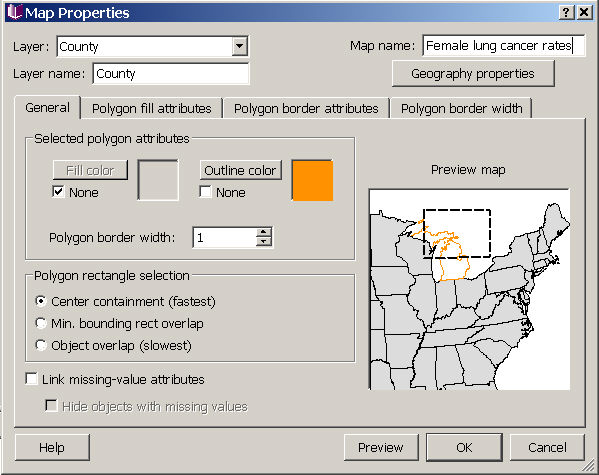
Selected polygon attributes
You can change the fill color, outline color, and outline thickness for displaying the polygons you have selected on the map. Your choices are shown in the preview map on the right. As shown here, the default is to show selected polygons with an orange outline with a width of 1.
Rectangle select method
You can select polygons in the map in one of three ways: by overlapping your selection rectangle with any part of polygons (object overlap), overlapping with their minimum bounding rectangles (so selections could include polygons not actually touched by the selection rectangle), or by the selection rectangle overlapping the polygon's centroid (center containment, the fastest option and the default). When you change your choice, the preview map in the right portion of the dialog will update to show you which polygons would be selected by the same rectangle using each selection method.
Missing-value display
On the general tab, you can choose to link missing value attributes across all datasets used in the map, or to hide objects with missing values. These options, and other options related to how missing values are displayed in your maps are described in missing values in map view.