


Options for Showing Missing Values in Map View
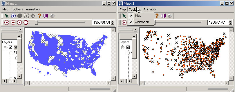
The default way for SpaceStat to represent missing values in polygon
data is to use a cross-hatched fill pattern, with transparent borders
of a width of "1". Similarly, as a default, SpaceStat
displays missing data in point files as an "X" of a given size,
color, and pattern. All of these parameters, as well as a similar
set for line files, can be changed through the  Map
Properties dialogs, under the Map pulldown menu in the Map window.
Map
Properties dialogs, under the Map pulldown menu in the Map window.
Note: missing values do not show up if you choose to color your polygons or points using the single color option, because this coloring option works at the geography level, rather than the dataset level. To simplify these maps and emphasize the missing values, we colored the polygons and points with data using a classified color scheme, and then changed all the fill colors for all classes to be the same.
Linking Missing Value Attributes
In some cases, you may want to use a map to show two or more different datasets simultaneously, and can implement this by, for example, using one dataset to determine the fill color scheme, and another to determine the polygon border width. If you keep the "link missing-value attributes" box checked on the General page within Map Properties for polygons, points, or lines, an object that is missing a value for any dataset will be shown in the map with all of the suite of parameters (i.e., fill color and pattern, line color and pattern, line width, or the appropriate parameters for point or line data) you choose for representing missing values. Keeping this box checked will lead to "Missing Values" showing up as a single attribute category (moving to the left, out from under the color, line, etc. headings) in the legend. If instead you want to be able to show which of your datasets is missing values for a particular object, uncheck this box - then the options you have used for representing missing values will be shown as a subcategory under attribute type. Then, if one dataset controls border width and the other controls fill color, you will be able to tell by looking at the characteristics of how objects are drawn to see which datasets have missing values.
Hiding Missing Values
If you want to prevent objects with missing values from being drawn, check the "hide objects with missing values" box on the General page within Map Properties for polygons, points, or lines.
Polygon Fill or Point/Line Color for Missing Values
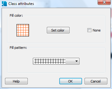
In the bottom right corner of the polygon fill attributes tab, the point color tab, and the line attributes tab you can choose how SpaceStat should fill polygons, or color points or lines, that have missing values by clicking the "set" button. For polygons, this will open the dialog box shown below, where you can choose the fill color and pattern. When you click "ok", the box on the polygon fill page that applies to missing values will be updated to reflect the choice you just made. Note that the global fill style (just above the missing value selection area) will not override the choice you made for missing value fill. A similar point/line color dialog is found when you go into map properties from a point- or line-based map.
Polygon Border Color and Style for Missing Values
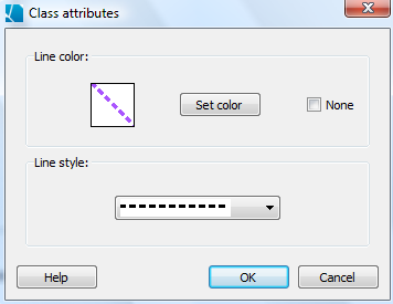
In the bottom right corner of the polygon border attributes page, you can choose how SpaceStat should draw the borders of polygons with missing values by clicking the "set" button. This will open the dialog box shown below, where you can choose the line color and style. When you click "ok", the box on the polygon border page that applies to missing values will be updated to reflect the choice you just made. Note that the global line style (just above the missing value selection area) will not override the choice you made for missing value borders.
Polygon Border Width and Line Width for Missing Values
The width of polygon borders for objects with missing values, or the width of lines with missing values can also differ from the width for polygons or lines with data. A box for filling in a line width for objects with missing values is in the lower right corner of the polygon border width or line width page of Map Properties.
Point Size and Symbols for Missing Values
The size of points with missing values can be changed on the lower right corner of the point size tab that is found in the Map Properties options for point geographies. Similarly, you can change the symbol for missing values (an "X" is the default) on the Map Properties, point symbol attributes tab.