


Troubleshooting
Problems importing problem files
I have a problem file from an analysis in a previous version of SpaceStat, but I don't have the shapefile that goes with it.
Older versions of SpaceStat used spatial weight sets to define neighbor relationships between objects, but did not have the visualization capabilities to map these objects. The space-time platform on which SpaceStat 2.0 and beyond was built requires that all imported data have a spatial and temporal component. This allows SpaceStat to create sophisticated maps that can be animated through time.
If you do not have a shapefile or some other geographic file there still is a way in which you can import this data into the new SpaceStat. You will be able to conduct analyses which use the information found in the spatial weight set, but you will not be able to map this data.
To import a problem file, go to File -> Import > SpaceStat 1.x
file. You may also select the  icon on
the toolbar and choose SpaceStat 1.x. When you click on SpaceStat
1.x file, hold down the SHIFT key. The following dialog will appear.
icon on
the toolbar and choose SpaceStat 1.x. When you click on SpaceStat
1.x file, hold down the SHIFT key. The following dialog will appear.
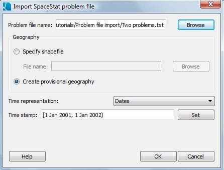
This is similar to the usual import problem file dialog except there is an option to create a provisional geography. This type of geography is created from randomly generated points and serves only to host the datasets and spatial weight sets that are associated with the problem file. You will be able to run any analysis that uses spatial weight sets but will not be able to map the objects (since the geographical location of the objects have no relationship to the data or spatial weight sets). Also, you will not be able to create new spatial weight sets or create variogram clouds for the same reason. Any methods which reference the geographic locations of the objects, such as Turnbull's or Besag & Newell, can not be performed with provisional geographies.
In the Data View, provisional geographies will use the old SpaceStat
icon instead of the icon for polygon  or point
  geographies.
Problems importing shapefiles
Click here to see information on export-related problems
I imported a shapefile, but I get an error message when I try to merge a newly imported shapefile or DBF to it.
This happens when the parent or original geography does not have any datasets which can serve as an ID field (the ID field is used to join the datasets and must be integer or string, each value unique). You may need to convert the type of a dataset to make it fit the requirements.
This can also happen if you have multiple objects in your shapefile with the same ID. This can occur if a complex set of polygons is represented as separate rows in a DBF associated with a shapefile (so separate objects in the shapefile). To avoid this, you can merge polygons by ID when you import the shapefile.
I tried to import a large shapefile, and the import process seems to have stalled while SpaceStat calculates spatial weights.
If you have a very large geography, the import process may appear to hang up as SpaceStat calculate spatial weights. You can either be patient and wait for the calculations to be completed, or choose to skip the calculation of weights, and then calculate them later as needed for the use of particular statistical methods.
After I imported a shapefile, I see an error message about self-intersecting polygons
In some polygon geographies, polygons that share one ID have boundaries that self-intersect, which will trigger an error message from SpaceStat that will appear in the log view. For example, the message shown below comes up when you import the National Cancer Institute's State Economic Area geography (available from the NCI website). One of the polygons that self intersects is in Texas (see orange SEA on map). Information on how to identify this and other problematic polygons is given in the error message (bottom-left of image), which allows you to find them in the table and highlight them on the map.
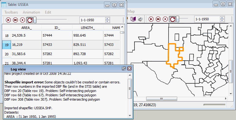
As you can see, SpaceStat maps these polygons and includes them in the tabular data. However, self intersecting polygons are excluded from Scale Conversion/Interpolation methods, so we note their presence as part of the import process. Often, you can make small edits in the shapefile (in a GIS software program) to correct this problem, and then re-import the file into SpaceStat (you can't edit polygon boundaries within SpaceStat).
Problems exporting shapefiles and datasets
I exported a shapefile from SpaceStat, but the datasets in the file can't be read by ESRI GIS software.
In some cases, when you try to use a shapefile exported from SpaceStat in ESRI's most recent ArcGIS products, you will get an error message that says "A column was specified that does not exist." When this error occurs, you will be able to view a map of the shapefile in ArcMap, but won't be able to open the associated table (dbf file). This error does not occur if you try to bring the exported shapefile into older ESRI products (i.e., ArcView 3.2), or into free GIS programs (i.e., DIVA). The problem appears to be related to the ArcGIS products not being able to handle spaces in the names (headers) of datasets. So, you can either remove these spaces in your dataset names before trying to export the shapefile, or can edit the dbf component of the shapefile (in Microsoft Excel or some other program) after you export it from SpaceStat, but before you try to import it. Note, dataset names are also truncated when you export them from SpaceStat, so if you do your name editing prior to export, you may wish to shorten one with similar suffixes so that you can tell them apart after you export.
I exported datasets (or a shapefile) from SpaceStat, and in the output dbf, some datasets now have the same name.
When SpaceStat exports datasets (tabular data), the column headers are truncated at 10 characters. If you are exporting datasets that represent output from various statistical procedures (which sometimes have long "output" names), you may find that when the names are truncated, you can no longer tell the datasets apart because the first 10 characters in their names are the same (i.e., you are exporting data from several runs of the same statistical method, perhaps with different parameter values). The solution is to right click on the dataset names prior to exporting them, and use the "rename dataset" option to shorten the name to 10 characters or less.