


Illinois Population Projections Tutorial
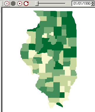
In this exercise, we will import two files: a shapefile of Illinois counties and a DBF of population estimates for each county from 1990 to 2020. We will then interpolate and animate the data within SpaceStat to watch how the population of each county changes over time. The image below should show an animated map (Help: I don't see this image animate).
About the data
When this tutorial was first created, the population projection data were available from the Illinois State University's Census and Data Users Service, a program that unfortunately is no longer funded by the state of Illinois. The former home of this program was accessible through the LILT website at Illinois State, and you may be able to get more information about these data through contacts from that site.
To prepare this tutorial, we took the original set of projections and turned them into a DBF for merging these datasets with the county geography within SpaceStat. Feel free to open the DBF in Excel and save it as an Excel file (.xls) if you would prefer to work in that format -- all instructions here will work with either file format.