Export Weights File
You can export a spatial weights set as a binary contiguity file (*.gal) or generalized weights format (*.gwt) file. Both of these files can be read with a text editor or imported into a spreadsheet. The main difference between these two formats is that binary contiguity files contain information on neighbor relationships only, while generalized weights files hold information on neighbors and weight values.
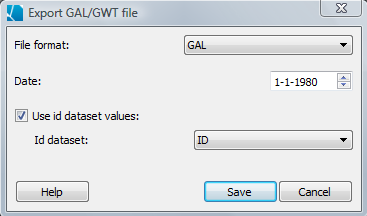
Choose to export a GAL or a GWT file by right-clicking on a weights set in the weights set view (marked "weights view" in the middle left of this screen shot) and choosing "Export" from the pop-up menu. You will then need to choose whether to export a GAL or GWT file, a date and/or time (a field will appear for entering the time if that is appropriate for your weight file) and an ID dataset to use, if you choose to use one. The IDs are used to identify locations in the exported file. Only unique variables without any missing values at the time specified will show up in the "ID dataset" drop-down. If you choose a time outside the range of your data, no ID datasets will be available. If you choose not to assign an ID dataset, the objects will be identified by the order in which they were imported or created, as they are originally displayed in the Table View.