


View Spatial Weights
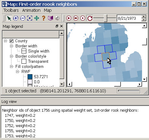
You can view spatial weights in the map and log by selecting an individual object (or set of objects) and directing SpaceStat to show you the neighbors. For example, the polygons with blue borders in the image to the right are the first-order rook neighbors of the orange-bordered polygon. Using the "Show object neighbors" function will also add the neighbor IDs and their weights to the log. The numbers shown before the weights values will be from the ID dataset, which is also visible in the table, or by querying the object in the map. Note that if you need a reminder of the name of the ID dataset in your project, this information is displayed at top of the Log view.
Steps
-
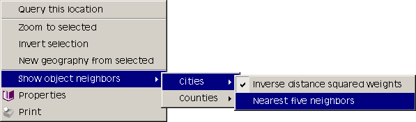
Right click on a map and choose "Show object neighbors". If there are multiple layers in the map and multiple weights sets, you will need to choose a weights set for each layer you want to see. The weight selection step enables the "Show neighbors" functionality.
-
Each object you click with the selection pointer
 will be highlighted in the selection
color (orange is the default). Its neighbors will be highlighted
in blue, with the weights reported in the log.
If ego is included in
your weight calculation, then the selected area will also be highlighted
in blue, and it will be listed as a neighbor and have a weight in
the log. It is possible to select multiple objects to view several
sets of neighbors at once using the Shift key.
will be highlighted in the selection
color (orange is the default). Its neighbors will be highlighted
in blue, with the weights reported in the log.
If ego is included in
your weight calculation, then the selected area will also be highlighted
in blue, and it will be listed as a neighbor and have a weight in
the log. It is possible to select multiple objects to view several
sets of neighbors at once using the Shift key. -
You have the option to zoom, pan, and query as usual, but the selection pointer
will select
objects and show their neighbors in blue until you turn off the functionality. -
To stop showing neighbors, right click on the map, select "Show object neighbors" and then uncheck the chosen weights set(s). When all sets have been cleared, the selection pointer returns to its normal state.