Map Properties for Polygons - Fill Attributes Tab
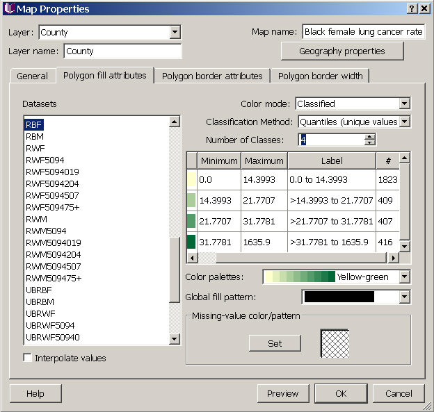
In the Map Properties fill attribute dialog for polygons, you can choose which dataset to use to color the polygons (by selecting the dataset from the data sets column on the lower left - the map displays a single dataset in each layer), and then you can customize the color mode and color scheme (options are listed in the pull-down menu next to "Color palettes". Datasets can be represented in one of several color modes: single color, qualitative, classified, or continuous. To create "custom" categories, choose the classified option, choose custom for the classification method, and then enter the number of classes. You can then type in Min and Max values for each group. Once you have divided the data, you can further modify how each category is colored and filled by clicking on the colored box for each group (in the fill column, which is partially hidden in the image below -- to the left of the "Minimum" column). You can also change the fill pattern for all data categories (Global fill pattern), and the fill pattern for missing values (see bottom right of dialog box).
By checking the box in the lower left (below the list of datasets), you can choose to have SpaceStat interpolate values during animations or map movies to smooth the transitions between different fill types if an object's fill class changes over time.
Choose "Preview" to view your selections in the map (don't close the properties dialog box while you preview, or your changes will be lost). When you have finished choosing a fill scheme, choose "OK" to apply your changes and close the dialog. If you press "Cancel" after "Preview" your changes will not be saved.
Click on tabs and boxes in the image below for more information.