
In our fast-paced world, rapid analysis is essential to reach plausible explanations with known amounts of certainty. Researchers have previously identified endeavors where Vesta provides forecasting and an understanding of the current determinants.
Vesta offers unique features that make rapid analysis possible: Time-enabled, linked windows, statistical and cartographic brushing, missing values handling, and space-time geostatistics. With these features, users can understand disease prevention, evaluate policy, identify impacted populations, and optimize treatment facilities.
The health and environment data come from multiple sources and must be imported and time-stamped to create animated map layers for visualization and analysis. Vesta’s input algorithms are aware of the different formats used for health-environment data, and automatically locate the field identifiers necessary for analysis. With data import accomplished, every environmental health analysis follows five integrated steps.
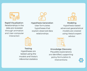
The first step, rapid visualization using statistical and cartographic brushing, is critical and is best illustrated using a video.
The video illustrates how statistical and cartographic brushing results in a rapid understanding of the patterns in the data. With this understanding, the user begins to ask that critical “why” question that leads to the “I think …” moment. And that is how a hypothesis is generated.
1. Time-enabled: Handles space-time referencing, time-stamped data, space-time queries, and temporal animation. Linked windows: Links space-time referenced objects in different windows being used to visualize the data. Cartographic and statistical brushing: Supports user selection (“brushing”) on maps and statistical graphics to rapidly explore how geographic location impacts data distributions and characteristics. Missing values: Missing values are handled appropriately in visualization and statistical analyses. Space-time geostatistics: Allow advanced modeling of data distributions and forecasting over geographic space and through time.