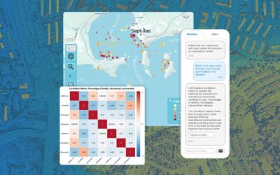
Picture this: it's 2019, and veterinary epidemiologists in Vietnam are watching African swine fever spread commune by commune across the country. Within months, the virus reaches more than half the country's provinces and devastates over five million pigs. The...
Geospatial Data & Analysis Posts
How To Overcome The Geospatial Data Crisis
by Geoffrey Jacquez, Ph.D. | May 22, 2026 | Geospatial Data & Analysis
The Problem Nobody Talks About Spatial analysis is one of the most powerful tools available to practitioners in public health, epidemiology, environmental science, ecology, and beyond. The ability to reveal geographic patterns in disease incidence, identify...
Why Does Most Geospatial AI Fall Short? How Vesta’s AI Advisor Gets It Right
by Geoffrey Jacquez, Ph.D. | May 21, 2026 | Geospatial Data & Analysis, GIS Technology
LLMs are flooding into GIS platforms. But authoritative geospatial intelligence requires more than a chatbot bolted onto a map. Here's what the gap looks like — and how Vesta fills it. The AI gold rush in GIS: a lot of noise, not enough signal Artificial intelligence...
How Spatial Autocorrelation Works: The Four Laws of Spatial Pattern
by Geoffrey Jacquez, Ph.D. | Jan 14, 2026 | Geospatial Data & Analysis, Learn with BioMedware
Here's a problem that trips up even experienced analysts: you build a model using geographic data, the statistics look solid, and then your predictions fall apart in the real world. Often, the culprit is something hiding in plain sight: spatial autocorrelation....
What is Kriging? The Workhorse of Geostatistics
by Pierre Goovaerts, Ph.D. | Dec 17, 2025 | Geospatial Data & Analysis
In the world of spatial analysis, where data points are scattered across a landscape, a fundamental question arises: how can we estimate the value at a location we haven't sampled? For most geoscientists, the answer is kriging. Far more than a simple interpolation...
Why Space-Time Analysis Matters: Visualizing and Understanding Real-World Processes with Vesta
by Geoffrey Jacquez, Ph.D. | Dec 10, 2025 | Geospatial Data & Analysis, Learn with BioMedware
“From now on, space by itself and time by itself are doomed to fade away into mere shadows, and only a kind of union of the two will preserve an independent reality.” — Hermann Minkowski, 1908 More than a century after Minkowski made this observation, his insight...
Compositional Data Analysis in Geostatistics: Navigating the Closed-Space Conundrum
by Pierre Goovaerts, Ph.D. | Dec 2, 2025 | Geospatial Data & Analysis
A significant portion of the data analyzed geostatistically doesn’t consist of simple numerical values like temperature or elevation. Instead, we often deal with compositional data—parts of a whole that are constrained to sum to a constant. Think of a rock sample's...
Utilizing Time Plots in Vesta (Including Video Demo)
by Geoffrey Jacquez, Ph.D. | Nov 24, 2025 | Geospatial Data & Analysis, Learn with BioMedware
Temporal trends are central in many fields—from epidemiology, economics, policy to environmental science. Being able to track how a variable changes over time, and link that change back to space or other covariates, is powerful. In BioMedware’s Vesta software, time...
What Is Geospatial Analysis?
by Geoffrey Jacquez, Ph.D. | Nov 12, 2025 | Geospatial Data & Analysis
In an era of rapidly expanding data and ever-shifting landscapes—both physical and digital—the ability to make sense of where things occur, when they occur, and why they occur has become ever more critical. That’s the realm of geospatial analysis: a set of tools,...
Exclusive Webinar: Modeling Change Over Space and Time with Vesta
by Ioana Nadra | Oct 1, 2025 | BioMedware News, Geospatial Data & Analysis
When analyzing data that changes across both time and geography, most researchers face a critical challenge: identifying exactly when and where significant trend shifts occur. Traditional GIS tools force you to choose between temporal analysis or spatial analysis—but...


