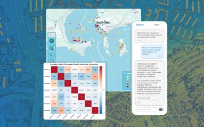
I can see the pattern — but what does it mean? You’ve spent hours assembling your data. You geocoded the records, loaded the basemap, and produced a choropleth. The cluster is apparent — but you don’t know whether it is real or random, growing or fading, or what is...
Geoffrey Jacquez, Ph.D. Posts
What Is Geospatial Mapping? How Does It Work?
by Geoffrey Jacquez, Ph.D. | May 27, 2026 | Geospatial Data & Analysis
Picture this: it's 2019, and veterinary epidemiologists in Vietnam are watching African swine fever spread commune by commune across the country. Within months, the virus reaches more than half the country's provinces and devastates over five million pigs. The...
How To Overcome The Geospatial Data Crisis
by Geoffrey Jacquez, Ph.D. | May 22, 2026 | Geospatial Data & Analysis
The Problem Nobody Talks About Spatial analysis is one of the most powerful tools available to practitioners in public health, epidemiology, environmental science, ecology, and beyond. The ability to reveal geographic patterns in disease incidence, identify...
Why Does Most Geospatial AI Fall Short? How Vesta’s AI Advisor Gets It Right
by Geoffrey Jacquez, Ph.D. | May 21, 2026 | Geospatial Data & Analysis, GIS Technology
LLMs are flooding into GIS platforms. But authoritative geospatial intelligence requires more than a chatbot bolted onto a map. Here's what the gap looks like — and how Vesta fills it. The AI gold rush in GIS: a lot of noise, not enough signal Artificial intelligence...
How Spatial Autocorrelation Works: The Four Laws of Spatial Pattern
by Geoffrey Jacquez, Ph.D. | Jan 14, 2026 | Geospatial Data & Analysis, Learn with BioMedware
Here's a problem that trips up even experienced analysts: you build a model using geographic data, the statistics look solid, and then your predictions fall apart in the real world. Often, the culprit is something hiding in plain sight: spatial autocorrelation....
Why Space-Time Analysis Matters: Visualizing and Understanding Real-World Processes with Vesta
by Geoffrey Jacquez, Ph.D. | Dec 10, 2025 | Geospatial Data & Analysis, Learn with BioMedware
“From now on, space by itself and time by itself are doomed to fade away into mere shadows, and only a kind of union of the two will preserve an independent reality.” — Hermann Minkowski, 1908 More than a century after Minkowski made this observation, his insight...
Utilizing Time Plots in Vesta (Including Video Demo)
by Geoffrey Jacquez, Ph.D. | Nov 24, 2025 | Geospatial Data & Analysis, Learn with BioMedware
Temporal trends are central in many fields—from epidemiology, economics, policy to environmental science. Being able to track how a variable changes over time, and link that change back to space or other covariates, is powerful. In BioMedware’s Vesta software, time...
What Is Geospatial Analysis?
by Geoffrey Jacquez, Ph.D. | Nov 12, 2025 | Geospatial Data & Analysis
In an era of rapidly expanding data and ever-shifting landscapes—both physical and digital—the ability to make sense of where things occur, when they occur, and why they occur has become ever more critical. That’s the realm of geospatial analysis: a set of tools,...
Introducing Vesta 2.8: Powerful New Tools for Spatial & Temporal Analysis
by Geoffrey Jacquez, Ph.D. | Sep 18, 2025 | BioMedware News, GIS Technology
We’re excited to announce the release of Vesta 2.8, the latest update to BioMedware’s premier software for spatial and temporal data analysis. Building on the major innovations we introduced in version 2.7, this update brings new features, refinements, and important...
Geospatial Analysis in the Hunt for Blue Zones
by Geoffrey Jacquez, Ph.D. | Aug 13, 2025 | Geospatial Data & Analysis
What Are Blue Zones? Imagine living in a place where people routinely celebrate their 90th or even 100th birthday while remaining active and vibrant. These exceptional regions, where longevity isn't an anomaly but a community norm, are known as Blue Zones. First...


