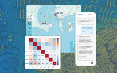
LLMs are flooding into GIS platforms. But authoritative geospatial intelligence requires more than a chatbot bolted onto a map. Here's what the gap looks like — and how Vesta fills it. The AI gold rush in GIS: a lot of noise, not enough signal Artificial intelligence...
GIS Technology Posts
Why Your GIS Tools Are Missing Critical Trend Shifts (And What to Do About It)
by Ioana Nadra | Nov 18, 2025 | GIS Technology, Learn with BioMedware
When analyzing datasets that evolve across time and geography—disease outbreaks, environmental changes, demographic shifts—most researchers face a fundamental limitation: their tools force them to choose between temporal analysis or spatial analysis, but not both...
Introducing Vesta 2.8: Powerful New Tools for Spatial & Temporal Analysis
by Geoffrey Jacquez, Ph.D. | Sep 18, 2025 | BioMedware News, GIS Technology
We’re excited to announce the release of Vesta 2.8, the latest update to BioMedware’s premier software for spatial and temporal data analysis. Building on the major innovations we introduced in version 2.7, this update brings new features, refinements, and important...
Tracking and Analyzing Antimicrobial-Resistant Infections in Vesta
by Geoffrey Jacquez, Ph.D. | Jul 23, 2025 | GIS Technology
Antimicrobial resistance (AMR) poses a significant threat to global health, with bacterial resistance leading to increased mortality, prolonged hospital stays, and higher medical costs. The Lancet's recent publication highlights the escalating burden of AMR,...
What Is a Geographic Information System?
by Geoffrey Jacquez, Ph.D. | Jul 8, 2025 | GIS Technology, Learn with BioMedware
Every time you check your weather app, navigate with GPS, or track a package on its journey to your doorstep, you’re using the power of Geographic Information Systems (GIS). While most people interact with GIS daily without even realizing it, this behind-the-scenes...
What’s The Difference Between Google Maps, GIS, and Vesta?
by Geoffrey Jacquez, Ph.D. | Jun 16, 2025 | GIS Technology
For most of us, Google Maps is a daily companion. It gets us from point A to B, helps us find the best local coffee shop, and even shows us what our dream vacation spot looks like from street level. But have you ever wondered about the technology that powers this...
Geospatial Analysis in Environmental Monitoring and Preservation
by Geoffrey Jacquez, Ph.D. | Jun 4, 2025 | Geospatial Data & Analysis, GIS Technology
An Introduction to Environmental Monitoring and Geospatial Analysis How are humans impacting our environment? Public awareness of human impacts on the environment was significantly heightened by the publication of Silent Spring by Rachel Carson in 1962. The book...
GIS and Smart Cities: Mapping the Future
by Geoffrey Jacquez, Ph.D. | Apr 14, 2025 | GIS Technology
Picture this: You're cruising through a city where traffic flows smoothly, every building efficiently uses energy, and emergencies are resolved before they even escalate. Welcome to the world of smart cities, where GIS (Geographic Information Systems) is the unsung...
Introducing Vesta 2.6: Smarter, Simpler, and More Powerful
by Geoffrey Jacquez, Ph.D. | Feb 21, 2025 | BioMedware News, GIS Technology
We’re excited to announce the release of Vesta 2.6—an update that takes BioMedware’s proprietary GIS software to the next level. Vesta 2.5 introduced time plots, indicator Kriging, and categorical variables in Variography and Kriging. This version makes powerful...
Understanding Joinpoint Regression Software
by Geoffrey Jacquez, Ph.D. | Feb 5, 2025 | GIS Technology
The new release of Vesta includes the Joinpoint Regression method that builds upon the techniques and software developed by the National Cancer Institute’s Surveillance program. NCI’s Joinpoint focuses on cancer rates and trends; at BioMedware, we see much wider...


