LLMs are flooding into GIS platforms. But authoritative geospatial intelligence requires more than a chatbot bolted onto a map. Here’s what the gap looks like — and how Vesta fills it.
The AI gold rush in GIS: a lot of noise, not enough signal
Artificial intelligence has arrived in geospatial software with considerable fanfare. Major GIS vendors have raced to embed LLMs into their platforms, promising natural language interfaces, automated workflows, and intelligent analysis. The pitch is intriguing: ask a question in plain English, get an answer about your spatial data.
But as users spend time with most of these tools, a distinct pattern emerges. The AI can find a method, propose a vague workflow, or summarize a result in seconds, but it doesn’t actually understand the spatial statistics it’s recommending. Ask it why it chose a particular kernel bandwidth, whether your data meets the assumptions of spatial autocorrelation analysis, or how to handle boundary effects in areal data, and the confident tone continues, even when the answer is wrong.
The fundamental problem: a general-purpose LLM trained on the entire internet is not the same thing as a curated, authoritative geospatial intelligence system. Garbage in, garbage out has always been the cardinal rule of data analysis. Geospatial AI is no exception.
The core question to ask of any “AI-powered” GIS tool: Is the AI actually trained on authoritative spatial statistics knowledge? Does it understand your specific data, methods, and project context? Can it execute — not just suggest — the right analysis? Or is it a general-purpose LLM wearing a map-themed hat?
The four gaps in today’s geospatial AI
Through years of working with spatial analysts, epidemiologists, and GIS professionals, the BioMedware team has identified the gaps where generic AI tools consistently fail researchers and users who need real answers.

Introducing the Vesta Advisor: geospatial intelligence that works
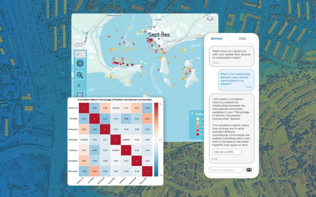
Vesta’s AI Advisor is a fully integrated LLM system purpose-built for spatial statistics and geospatial analysis. It isn’t a general chatbot with a map widget — it’s an intelligent analysis partner that understands the methods, knows your data, and can take action. Here’s what that looks like in practice.
1. A natural language interface that understands spatial statistics
Ask the Vesta Advisor about your data in plain English. Whether you’re a seasoned geostatistician or a researcher new to spatial analysis, you can describe what you want to know — and the Advisor will translate that into precise, methodologically grounded guidance. “What’s the spatial pattern of disease incidence in this dataset?” becomes a step-by-step workflow recommendation rather than a generic paragraph about cluster analysis.
2. Full project context awareness
Vesta Advisor keeps your current project state up to date at all times, including which datasets are loaded, which variables are available, which analyses have already been run, and which visualizations exist. This context-awareness means recommendations are specific to your work, not generic templates. It won’t suggest a method that requires data you don’t have, or a visualization that duplicates one you’ve already built.
3. Action execution, not just advice
This is where Vesta’s Advisor diverges most sharply from the field. Rather than handing you a to-do list, the Advisor can act: it creates maps, runs statistical analyses, generates histograms and charts, renames and converts variables, and organizes your workspace — all through natural conversation. Ask it to run a spatial autocorrelation analysis on your outcome variable and visualize the result, and it does exactly that.
| Automated visualization | Creates maps, charts, and histograms on request — no manual steps required. |
| Analysis execution | Runs spatial statistics workflows directly from natural language requests. |
| Data operations | Renames datasets, converts variables, and manages workspace organization. |
| Continuous learning | Improves from every correction and interaction, synced across your team. |
4. RAG-powered authority: curated knowledge, not internet trivia
Vesta’s Advisor uses Retrieval-Augmented Generation (RAG) to ground every response in a curated knowledge base of validated spatial statistics methods and workflows. This isn’t a model trained on Reddit threads and Stack Overflow posts — it’s a system anchored to authoritative geospatial methodology. When you ask about variogram modeling, spatial regression, or disease cluster detection, the answer comes from a knowledge base built and maintained by spatial statistics experts.
The RAG system also learns continuously. User corrections and feedback are automatically converted into new training examples, improving recommendation quality over time. Training data is synchronized across installations, so your team’s collective expertise compounds.
5. Intelligent action validation
Before executing any suggested action, the Advisor validates it against your current project state:
- Do the referenced datasets exist?
- Are the required variables present?
- Is the method appropriate for the data structure?
This pre-validation catches errors before they happen, which is something no general-purpose LLM can do without deep integration into the analysis environment.
6. Flexible LLM backends with smart routing
Vesta supports multiple LLM backends, including direct OpenAI API integration and a proxy service for users without API keys. Intelligent routing selects the optimal backend based on availability and your configuration — so the Advisor is always available when you need it.
Who benefits from Vesta’s AI Advisor?
Vesta’s Advisor was designed for the full spectrum of geospatial practitioners — from seasoned GIS experts to researchers who work with spatial data every day but don’t consider themselves GIS users.
GIS professionals
Vesta Advisor accelerates workflows, automating repetitive data operations, generating visualizations on demand, and validating analytical steps before execution. Spend less time managing software and more time interpreting results.
- Run spatial autocorrelation, regression, and cluster analyses through conversation rather than menus
- Automate map and chart generation without manual configuration
- Get instant validation that datasets, variables, and methods are aligned before a long analysis runs
Spatial epidemiologists
Whether you’re tracking disease clusters, modeling environmental exposures, or analyzing health outcome disparities, Vesta Advisor understands the methods you rely on and can guide or execute them with methodological precision.
- Ask plain-English questions about spatial patterns in your outcome data and get grounded, actionable guidance
- Run cluster detection and spatial regression workflows without deep GIS training
- Keep sensitive registry and surveillance data local (data never leaves the environment)
Geostatisticians
Vesta Advisor is fluent in the language of geostatistics, including variography, kriging, spatial interpolation, and beyond. It selects methods intelligently, validates assumptions, and suggests logical next steps based on your results.
- Get method recommendations grounded in a curated, authoritative spatial statistics knowledge base
- Automate variogram fitting and kriging workflows through natural language
- Receive proactive suggestions for follow-on analyses based on what your results show
Researchers and analysts new to geospatial methods
Vesta Advisor is for ecologists, public health scientists, urban planners, veterinary epidemiologists, and food safety researchers who work with spatial data but lack formal GIS training. It lowers the barrier to sophisticated spatial analysis without lowering the quality of the results.
- Ask questions about your data in plain English and receive step-by-step methodological guidance
- Execute analyses without navigating complex GIS interfaces or learning specialist software
- Get the analytical rigor of expert spatial methods, guided by an AI that understands the science
Frequently Asked Questions About Geospatial AI
What makes Vesta’s AI Advisor different from AI tools in Esri or QGIS?
Most GIS platform AI integrations use general-purpose LLMs with minimal spatial statistics grounding. Vesta’s Advisor is purpose-built: it uses RAG against a curated spatial methods knowledge base, is fully aware of your project context, and can execute analyses — not just recommend them.
Do I need to provide my own OpenAI API key to use the Vesta Advisor?
No. Vesta offers a proxy service for users who don’t have API keys. If you do have an OpenAI key, you can connect it directly for optimal performance. The system routes intelligently between backends.
How does the Vesta Advisor learn from my feedback?
When you correct or refine an Advisor recommendation, that interaction is automatically converted into a training example and added to your knowledge base. The system tracks quality scores over time and syncs training data across all installations — so your team’s corrections improve everyone’s experience.
Can the Vesta Advisor run analyses on large datasets?
Yes. The Advisor supports both quick operations and long-running analyses, with thread-safe execution and real-time UI updates. It handles error states gracefully and keeps you informed throughout.
Is the Vesta Advisor suitable for non-GIS researchers?
Absolutely — this is a core design goal. The natural language interface means you don’t need GIS expertise to run sophisticated spatial analyses. The Advisor guides you through method selection, data requirements, and interpretation in plain English.
Geospatial AI Next Steps
Geospatial AI is a real capability, but only when it’s built with the right foundations. Authority, context, execution, and continuous learning aren’t nice-to-haves; they’re the difference between an AI that helps you do better science and one that confidently leads you astray.
Vesta’s AI Advisor was built to close that gap: a curated, context-aware, action-capable geospatial intelligence system designed for the full range of spatial analysts. Whether you’re modeling infectious disease spread, mapping environmental exposures, or performing site suitability analysis, Vesta Advisor is the analytical partner that actually understands what you’re doing — and can help you do it better.
Learn more about Vesta and download it for free for 30 days.